
格尔木市 topographic map
Interactive map
Click on the map to display elevation.
About this map
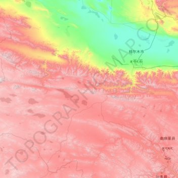
Name: 格尔木市 topographic map, elevation, terrain.
Location: 格尔木市, 海西蒙古族藏族自治州, 青海省, 816099, 中国 (33.86662 90.70461 37.76241 95.80439)
Average elevation: 4,101 m
Minimum elevation: 2,670 m
Maximum elevation: 6,054 m
地处青藏高原腹地,辖区由柴达木盆地中南部和飞地唐古拉山镇等区域组成,市区位于柴达木盆地中南部格尔木河冲积平原上,市区平均海拔2780米。面积为5856平方公里的察尔汗盐湖是中国最大的钾镁盐矿床,因此格尔木也有中国盐湖城之称。
Other topographic maps
Click on a map to view its topography, its elevation and its terrain.