
Thank you for supporting this site ❤️
Make a donation
Make a donation
Rheine topographic map
Click on the map to display elevation.
Thank you for supporting this site ❤️
Make a donation
Make a donation
About this map
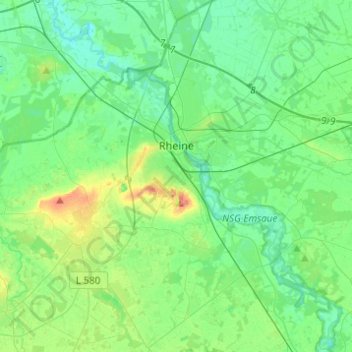
Name: Rheine topographic map, elevation, terrain.
Location: Rheine, Kreis Steinfurt, North Rhine-Westphalia, Germany (52.19188 7.36551 52.34180 7.58610)
Average elevation: 44 m
Minimum elevation: 26 m
Maximum elevation: 98 m
Thank you for supporting this site ❤️
Make a donation
Make a donation
Other topographic maps
Click on a map to view its topography, its elevation and its terrain.
Dorfbauernschaft
Germany > North Rhine-Westphalia > Kreis Steinfurt > Emsdetten
Average elevation: 46 m
Lengerich
Germany > North Rhine-Westphalia > Kreis Steinfurt > Lengerich > Lengerich
Average elevation: 91 m