Collinsville topographic map
Interactive map
Click on the map to display elevation.
About this map
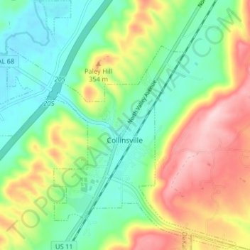
Name: Collinsville topographic map, elevation, terrain.
Location: Collinsville, DeKalb County, Alabama, 35961, United States (34.24127 -85.89692 34.29482 -85.83197)
Average elevation: 285 m
Minimum elevation: 199 m
Maximum elevation: 426 m
Other topographic maps
Click on a map to view its topography, its elevation and its terrain.
Fort Payne
United States > Alabama > DeKalb County
Fort Payne, DeKalb County, Alabama, 35967, United States
Average elevation: 369 m
Dawson
United States > Alabama > DeKalb County
Dawson, DeKalb County, Alabama, United States
Average elevation: 307 m
Camp Comer Dam
United States > Alabama > DeKalb County
Camp Comer Dam, DeKalb County, Alabama, 35984, United States
Average elevation: 490 m
Adamsburg
United States > Alabama > DeKalb County
Adamsburg, DeKalb County, Alabama, United States
Average elevation: 423 m
Mentone
United States > Alabama > DeKalb County
Mentone, DeKalb County, Alabama, 35984, United States
Average elevation: 470 m
Mentone
United States > Alabama > DeKalb County
Mentone, DeKalb County, Alabama, 35984, United States
Average elevation: 471 m
Henagar
United States > Alabama > DeKalb County
Henagar, DeKalb County, Alabama, 35978, United States
Average elevation: 436 m
Valley Head
United States > Alabama > DeKalb County
Valley Head, DeKalb County, Alabama, United States
Average elevation: 410 m
Rainsville
United States > Alabama > DeKalb County
Rainsville, DeKalb County, Alabama, 35986, United States
Average elevation: 380 m
Shiloh
United States > Alabama > DeKalb County
Shiloh, DeKalb County, Alabama, United States
Average elevation: 376 m
Hammondville
United States > Alabama > DeKalb County
Hammondville, DeKalb County, Alabama, United States
Average elevation: 362 m
Grove Oak
United States > Alabama > DeKalb County
Grove Oak, DeKalb County, Alabama, 35975, United States
Average elevation: 344 m
Lakeview
United States > Alabama > DeKalb County
Lakeview, DeKalb County, Alabama, United States
Average elevation: 344 m
Crossville
United States > Alabama > DeKalb County
Crossville, DeKalb County, Alabama, United States
Average elevation: 337 m
Powell
United States > Alabama > DeKalb County
Powell, DeKalb County, Alabama, United States
Average elevation: 381 m
Geraldine
United States > Alabama > DeKalb County
Geraldine, DeKalb County, Alabama, 35974, United States
Average elevation: 349 m
Fyffe
United States > Alabama > DeKalb County
Fyffe, DeKalb County, Alabama, 35971, United States
Average elevation: 376 m
Pine Ridge
United States > Alabama > DeKalb County
Pine Ridge, DeKalb County, Alabama, United States
Average elevation: 312 m
Desoto State Park
United States > Alabama > DeKalb County > Fort Payne
Desoto State Park, Fort Payne, DeKalb County, Alabama, United States
Average elevation: 454 m
Minvale
United States > Alabama > DeKalb County > Fort Payne > Minvale
Minvale, Fort Payne, DeKalb County, Alabama, 35967, United States
Average elevation: 322 m
Little River Canyon National Preserve
United States > Alabama > DeKalb County > Fort Payne
Little River Canyon National Preserve, Fort Payne, DeKalb County, Alabama, United States
Average elevation: 328 m
Collinsville
United States > Alabama > DeKalb County > Collinsville
Collinsville, DeKalb County, Alabama, 35961, United States
Average elevation: 285 m
Ider
United States > Alabama > DeKalb County
Ider, DeKalb County, Alabama, United States
Average elevation: 467 m
Fort Payne
United States > Alabama > DeKalb County > Fort Payne
Fort Payne, DeKalb County, Alabama, 35967, United States
Average elevation: 350 m
Red Hill
United States > Alabama > DeKalb County
Red Hill, DeKalb County, Alabama, United States
Average elevation: 255 m
Sylvania
United States > Alabama > DeKalb County
Sylvania, DeKalb County, Alabama, 35988, United States
Average elevation: 405 m