
Hohenau topographic map
Interactive map
Click on the map to display elevation.
About this map
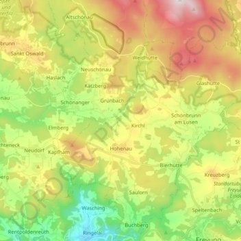
Name: Hohenau topographic map, elevation, terrain.
Location: Hohenau, Landkreis Freyung-Grafenau, Beieren, 94545, Duitsland (48.80931 13.44401 48.91500 13.57674)
Average elevation: 729 m
Minimum elevation: 401 m
Maximum elevation: 1,169 m
Other topographic maps
Click on a map to view its topography, its elevation and its terrain.
Freyung
Duitsland > Beieren > Landkreis Freyung-Grafenau
Freyung, Landkreis Freyung-Grafenau, Beieren, 94078, Duitsland
Average elevation: 695 m