
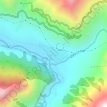
Baltal topographic map
Interactive map
Click on the map to display elevation.
About this map
Name: Baltal topographic map, elevation, terrain.
Average elevation: 3,160 m
Minimum elevation: 2,827 m
Maximum elevation: 3,976 m
Other topographic maps
Click on a map to view its topography, its elevation and its terrain.
Akhall Najwan
India > Jammu and Kashmir > Kangan
Akhall Najwan, Kangan, Ganderbal District, Jammu and Kashmir, India
Average elevation: 1,967 m
Sonamarg
India > Jammu and Kashmir > Kangan
Sonamarg, Kangan, Ganderbal District, Jammu and Kashmir, India
Average elevation: 3,068 m
Kullan
India > Jammu and Kashmir > Kangan
Kullan, Kangan, Ganderbal District, Jammu and Kashmir, India
Average elevation: 2,529 m
Hariganiwan
India > Jammu and Kashmir > Kangan
Hariganiwan, Kangan, Ganderbal District, Jammu and Kashmir, India
Average elevation: 2,268 m
Khanan
India > Jammu and Kashmir > Kangan
Khanan, Kangan, Ganderbal District, Jammu and Kashmir, 191202, India
Average elevation: 2,259 m
Anderwan
India > Jammu and Kashmir > Kangan
Anderwan, Kangan, Ganderbal District, Jammu and Kashmir, India
Average elevation: 2,348 m
Haripura
India > Jammu and Kashmir > Kangan
Haripura, Kangan, Ganderbal District, Jammu and Kashmir, 191201, India
Average elevation: 1,914 m
Chatergul
India > Jammu and Kashmir > Kangan
Chatergul, Kangan, Ganderbal District, Jammu and Kashmir, India
Average elevation: 2,073 m
Naranag
India > Jammu and Kashmir > Kangan > Naranag
Naranag, Kangan, Ganderbal district, Jammu and Kashmir, India
Average elevation: 2,736 m
Harmukh
India > Jammu and Kashmir > Kangan
Harmukh, Kangan, Ganderbal district, Jammu and Kashmir, India
Average elevation: 4,488 m