
Kent County topographic map
Interactive map
Click on the map to display elevation.
About this map
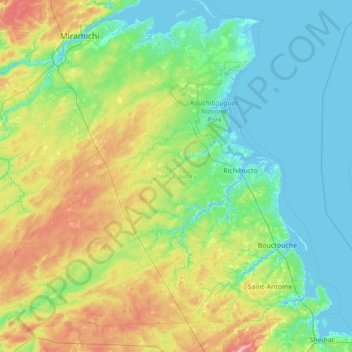
Name: Kent County topographic map, elevation, terrain.
Location: Kent County, New Brunswick, Canada (46.25654 -65.84754 47.05743 -64.47498)
Average elevation: 43 m
Minimum elevation: -4 m
Maximum elevation: 202 m
Other topographic maps
Click on a map to view its topography, its elevation and its terrain.
Clarendon Parish
Clarendon Parish, Charlotte County, New Brunswick, Canada
Average elevation: 160 m
Saint Quentin Parish
Saint Quentin Parish, Restigouche County, New Brunswick, E8A 1H5, Canada
Average elevation: 341 m
Oromocto
Canada > New Brunswick > Oromocto
Oromocto, Burton Parish, Sunbury County, New Brunswick, Canada
Average elevation: 24 m
Riverview
Canada > New Brunswick > Riverview
Riverview, Coverdale Parish, Albert County, New Brunswick, Canada
Average elevation: 41 m
Fundy National Park of Canada
Fundy National Park of Canada, 114, Alma Parish, Albert County, New Brunswick, E4H 1N5, Canada
Average elevation: 230 m