
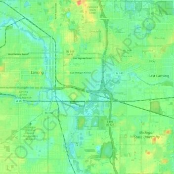
Lansing Charter Township topographic map
Interactive map
Click on the map to display elevation.
About this map
Name: Lansing Charter Township topographic map, elevation, terrain.
Average elevation: 262 m
Minimum elevation: 247 m
Maximum elevation: 289 m
Other topographic maps
Click on a map to view its topography, its elevation and its terrain.
Lansing
United States > Michigan > Ingham County
Lansing, Ingham County, Michigan, United States
Average elevation: 263 m
East Lansing
United States > Michigan > Ingham County
East Lansing, Ingham County, Michigan, United States
Average elevation: 261 m
Williamston
United States > Michigan > Ingham County
Williamston, Ingham County, Michigan, 48895, United States
Average elevation: 268 m
North Aurelius
United States > Michigan > Ingham County > North Aurelius
North Aurelius, Aurelius Township, Ingham County, Michigan, United States
Average elevation: 277 m
Mason
United States > Michigan > Ingham County > Mason
Mason, Ingham County, Michigan, 48854, United States
Average elevation: 276 m
Okemos
United States > Michigan > Ingham County > Okemos
Okemos, Meridian Charter Township, Ingham County, Michigan, United States
Average elevation: 264 m