
Thank you for supporting this site ❤️
Make a donation
Make a donation
Chestnut Hill topographic map
Click on the map to display elevation.
Thank you for supporting this site ❤️
Make a donation
Make a donation
About this map
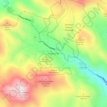
Name: Chestnut Hill topographic map, elevation, terrain.
Average elevation: 950 m
Minimum elevation: 631 m
Maximum elevation: 1,289 m
Thank you for supporting this site ❤️
Make a donation
Make a donation
Other topographic maps
Click on a map to view its topography, its elevation and its terrain.
Thank you for supporting this site ❤️
Make a donation
Make a donation
Thank you for supporting this site ❤️
Make a donation
Make a donation
Thank you for supporting this site ❤️
Make a donation
Make a donation
Mills River
United States > North Carolina > Henderson County > Mills River > Oak Hill Court
Average elevation: 644 m