
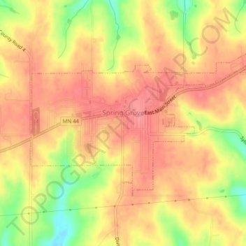
Spring Grove topographic map
Interactive map
Click on the map to display elevation.
About this map
Name: Spring Grove topographic map, elevation, terrain.
Average elevation: 385 m
Minimum elevation: 333 m
Maximum elevation: 411 m
Other topographic maps
Click on a map to view its topography, its elevation and its terrain.
La Crescent
United States > Minnesota > Houston County
La Crescent, Houston County, Minnesota, 55947, United States
Average elevation: 231 m
Pine Creek
United States > Minnesota > Houston County
Pine Creek, Houston County, Minnesota, United States
Average elevation: 283 m
Eitzen
United States > Minnesota > Houston County
Eitzen, Houston County, Minnesota, United States
Average elevation: 342 m
Willington Grove
United States > Minnesota > Houston County
Willington Grove, Houston County, Minnesota, United States
Average elevation: 366 m
South Ridge
United States > Minnesota > Houston County
South Ridge, Houston County, Minnesota, United States
Average elevation: 316 m
Wilmington
United States > Minnesota > Houston County
Wilmington, Houston County, Minnesota, United States
Average elevation: 355 m
Caledonia
United States > Minnesota > Houston County
Caledonia, Houston County, Minnesota, 55921, United States
Average elevation: 353 m
Bee
United States > Minnesota > Houston County
Bee, Houston County, Minnesota, United States
Average elevation: 324 m
Money Creek
United States > Minnesota > Houston County
Money Creek, Houston County, Minnesota, United States
Average elevation: 273 m
River Junction
United States > Minnesota > Houston County > La Crescent
River Junction, La Crescent, Houston County, Minnesota, 55947, United States
Average elevation: 233 m
Hokah
United States > Minnesota > Houston County
Hokah, Houston County, Minnesota, United States
Average elevation: 235 m
Newhouse
United States > Minnesota > Houston County
Newhouse, Houston County, Minnesota, 52131, United States
Average elevation: 359 m
Perkins
United States > Minnesota > Houston County
Perkins, Houston County, Minnesota, United States
Average elevation: 273 m
Schechs Mill
United States > Minnesota > Houston County > Sheldon
Schechs Mill, Sheldon, Houston County, Minnesota, United States
Average elevation: 305 m
Riceford
United States > Minnesota > Houston County
Riceford, Houston County, Minnesota, United States
Average elevation: 346 m
Sheldon
United States > Minnesota > Houston County
Sheldon, Houston County, Minnesota, United States
Average elevation: 298 m
Yucatan
United States > Minnesota > Houston County
Yucatan, Houston County, Minnesota, United States
Average elevation: 282 m
Brownsville
United States > Minnesota > Houston County
Brownsville, Houston County, Minnesota, United States
Average elevation: 247 m
Reno
United States > Minnesota > Houston County
Reno, Houston County, Minnesota, United States
Average elevation: 223 m