
Thank you for supporting this site ❤️
Make a donation
Make a donation
Cagayan Valley topographic map
Click on the map to display elevation.
Thank you for supporting this site ❤️
Make a donation
Make a donation
About this map
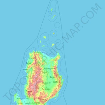
Name: Cagayan Valley topographic map, elevation, terrain.
Location: Cagayan Valley, Philippines (15.75792 120.73969 21.25729 122.66926)
Average elevation: 74 m
Minimum elevation: 0 m
Maximum elevation: 2,722 m
Thank you for supporting this site ❤️
Make a donation
Make a donation
Other topographic maps
Click on a map to view its topography, its elevation and its terrain.
Thank you for supporting this site ❤️
Make a donation
Make a donation
Thank you for supporting this site ❤️
Make a donation
Make a donation
Thank you for supporting this site ❤️
Make a donation
Make a donation
Santa
Philippines > Ilocos Sur > Santa
The topography of the municipality is undulating to rolling with slope ranging from 0-30%.
Average elevation: 75 m