
Make a donation
Pembrokeshire topographic map
Click on the map to display elevation.
Make a donation
Pembrokeshire
There is little evidence of Roman occupation in what is now Pembrokeshire. Ptolemy's Geography, written c. 150, mentioned some coastal places, two of which have been identified as the River Teifi and what is now St Davids Head, but most Roman writers did not mention the area; there may have been a Roman settlement near St Davids and a road from Bath, but this comes from a 14th-century writer. Any evidence for villas or Roman building materials reported by mediaeval or later writers has not been verified, though some remains near Dale were tentatively identified as Roman in character by topographer Richard Fenton in his Historical Tour of 1810. Fenton stated that he had "...reason to be of opinion that they had not colonized Pembrokeshire till near the decline of their empire in Britain".
Make a donation
About this map
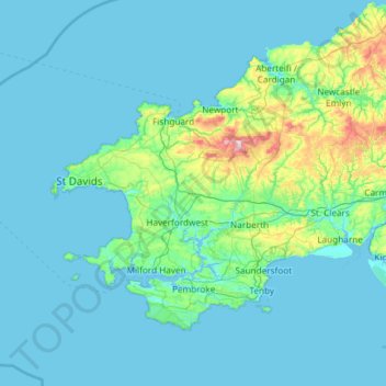
Name: Pembrokeshire topographic map, elevation, terrain.
Location: Pembrokeshire, Wales, United Kingdom (51.59592 -5.67030 52.11804 -4.48559)
Average elevation: 43 m
Minimum elevation: 0 m
Maximum elevation: 521 m
Make a donation
Other topographic maps
Click on a map to view its topography, its elevation and its terrain.
Swansea
United Kingdom > Wales > Swansea
Much of Swansea is hilly with the main area of upland being located in the council ward of Mawr. Areas up to 185 metres (607 ft) in elevation range across the central section: Kilvey Hill, Townhill and Llwynmawr separate the centre of Swansea from its northern suburbs. Cefn Bryn, a ridge of high land, is the…
Average elevation: 73 m
Make a donation
Make a donation
Make a donation
Make a donation
Make a donation
Make a donation
Make a donation
Make a donation
Knighton
United Kingdom > Wales > Powys
The town became a borough in 1203, with a charter permitting a weekly market and annual fair. The presence of two castles within a comparatively small town suggests that one (the earlier motte and bailey sited atop the town) went out of use before the establishment of the second (the motte with no bailey at…
Average elevation: 295 m
Make a donation
Aberystwyth
United Kingdom > Wales > Ceredigion
Aberystwyth experiences an oceanic climate (Köppen climate classification Cfb) similar to almost all of the United Kingdom. This is particularly pronounced due to its west coast location facing the Irish Sea. Air undergoes little land moderation and so temperatures closely reflect the sea temperature when…
Average elevation: 39 m
Make a donation
Make a donation
Make a donation
Make a donation
Make a donation
Make a donation
Make a donation
Make a donation
Make a donation
Morfa Harlech National Nature Reserve
United Kingdom > Wales > Gwynedd > Harlech
Average elevation: 3 m
Make a donation
Make a donation
Parc Tan-y-Bwlch
United Kingdom > Wales > Gwynedd > Mynydd Llandygái > Pen Y Bwlch
Average elevation: 293 m
Make a donation
Make a donation
Make a donation
Make a donation
Make a donation