
Lac Bowker topographic map
Interactive map
Click on the map to display elevation.
About this map
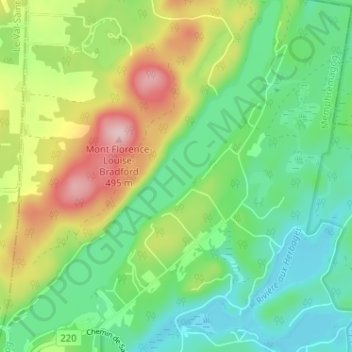
Name: Lac Bowker topographic map, elevation, terrain.
Location: Lac Bowker, Orford, Memphrémagog, Estrie, Québec, Canada (45.40133 -72.24143 45.44618 -72.19186)
Average elevation: 344 m
Minimum elevation: 266 m
Maximum elevation: 491 m
Other topographic maps
Click on a map to view its topography, its elevation and its terrain.
Mont Orford
Canada > Québec > Memphrémagog > Orford
Mont Orford, Orford, Memphrémagog, Estrie, Québec, J1X 0R4, Canada
Average elevation: 559 m
Lac de la Mine
Canada > Québec > Memphrémagog > Orford
Lac de la Mine, Orford, Memphrémagog, Estrie, Québec, Canada
Average elevation: 321 m