
Make a donation
Louisiana topographic map
Click on the map to display elevation.
Make a donation
Louisiana
The higher and contiguous hill lands of the north and northwestern part of the state have an area of more than 25,000 square miles (65,000 km2). They consist of prairie and woodlands. The elevations above sea level range from 10 feet (3 m) at the coast and swamp lands to 50–60 feet (15–18 m) at the prairie and alluvial lands. In the uplands and hills, the elevations rise to Driskill Mountain, the highest point in the state only 535 feet (163 m) above sea level. From 1932 to 2010 the state lost 1,800 square miles due to rises in sea level and erosion. The Louisiana Coastal Protection and Restoration Authority (CPRA) spends around $1 billion per year to help shore up and protect Louisiana shoreline and land in both federal and state funding.
Make a donation
About this map
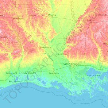
Name: Louisiana topographic map, elevation, terrain.
Location: Louisiana, United States (28.85429 -94.04319 33.01959 -88.75833)
Average elevation: 39 m
Minimum elevation: -4 m
Maximum elevation: 196 m
Make a donation
Other topographic maps
Click on a map to view its topography, its elevation and its terrain.
Make a donation
Fern Glen
United States > Pennsylvania > Luzerne County > Black Creek Township
Average elevation: 391 m
Make a donation
Trachsville
United States > Pennsylvania > Carbon County > Towamensing Township
Average elevation: 256 m
Make a donation
Make a donation
Make a donation
Cleveland
United States > Ohio > Cuyahoga County > Cleveland
The land rises quickly from the lake shore elevation of 569 feet. Public Square, less than one mile (1.6 km) inland, sits at an elevation of 650 feet (198 m), and Hopkins Airport, 5 miles (8 km) inland from the lake, is at an elevation of 791 feet (241 m).
Average elevation: 219 m
Make a donation
Glen Canyon Dam
United States > Arizona > Coconino County
The Bureau of Reclamation favored the Echo Park site over Glen Canyon, because its narrow canyons and high elevation (more than 5,000 feet (1,500 m), as compared to 3,700 feet (1,100 m) at Glen Canyon) would lead to less evaporation. It said that building Echo Park Dam and a "low" Glen Canyon Dam would save…
Average elevation: 1,171 m
Miami
United States > Florida > Miami-Dade County
Miami and its suburbs are located on a broad plain between the Everglades to the west and Biscayne Bay to the east, which extends from Lake Okeechobee southward to Florida Bay. The elevation of the area averages at around 6 ft (1.8 m)[39] above sea level in most neighborhoods, especially near the coast. The…
Average elevation: 4 m
Make a donation