
San Diego topographic map
Interactive map
Click on the map to display elevation.
About this map
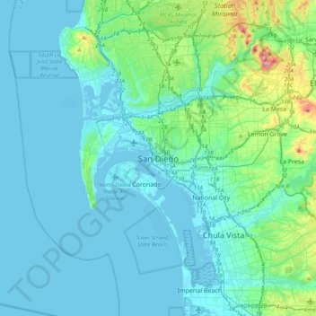
Name: San Diego topographic map, elevation, terrain.
Average elevation: 57 m
Minimum elevation: -10 m
Maximum elevation: 471 m
Other topographic maps
Click on a map to view its topography, its elevation and its terrain.
Vacation Isle
États-Unis d'Amérique > Californie > San Diego County > San Diego
Vacation Isle, Mission Beach, San Diego, San Diego County, Californie, États-Unis d'Amérique
Average elevation: 2 m
La Jolla
États-Unis d'Amérique > Californie > San Diego County > San Diego > La Jolla
La Jolla, San Diego, San Diego County, Californie, 92037, États-Unis d'Amérique
Average elevation: 37 m