
Yilan County topographic map
Interactive map
Click on the map to display elevation.
About this map
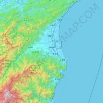
Name: Yilan County topographic map, elevation, terrain.
Location: Yilan County, Taiwan (24.30946 121.31766 24.98847 121.96588)
Average elevation: 472 m
Minimum elevation: -4 m
Maximum elevation: 3,689 m
Yilan County is located in the northeastern Taiwan Island which covers an area of 2,143 km2. The longest distance from east to west is 63 km and from north to south is 74 km. From the mountain areas downwards, the land falls in altitude in the stages of mountains, alleys, alluvial plains, lowlands, swamps, sand hills and finally coastline.
Other topographic maps
Click on a map to view its topography, its elevation and its terrain.
Pingtung City
Taiwan > Pingtung County > Pingtung County
Pingtung City, Pingtung County, 900, Taiwan
Average elevation: 24 m
Penglai
Taiwan > Taiwan Province > Nanzhuang > Penglai
Penglai, Penglai Village, Nanzhuang, Miaoli County, Taiwan Province, Taiwan
Average elevation: 638 m