
Montmeja topographic map
Interactive map
Click on the map to display elevation.
About this map
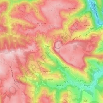
Name: Montmeja topographic map, elevation, terrain.
Average elevation: 485 m
Minimum elevation: 309 m
Maximum elevation: 578 m
Other topographic maps
Click on a map to view its topography, its elevation and its terrain.
Le Pont d'Estaing
France > Occitanie > Aveyron > Sébrazac
Le Pont d'Estaing, Sébrazac, Rodez, Aveyron, Occitanie, France métropolitaine, 12190, France
Average elevation: 429 m
La Bringuerie
France > Occitanie > Aveyron > Sébrazac
La Bringuerie, Sébrazac, Rodez, Aveyron, Occitanie, France métropolitaine, 12190, France
Average elevation: 459 m