
Werl topographic map
Interactive map
Click on the map to display elevation.
About this map
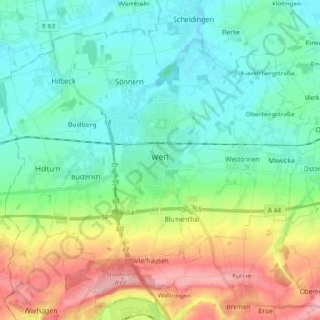
Name: Werl topographic map, elevation, terrain.
Location: Werl, Kreis Soest, North Rhine-Westphalia, 59457, Germany (51.50876 7.82709 51.59581 7.99856)
Average elevation: 122 m
Minimum elevation: 71 m
Maximum elevation: 245 m
Other topographic maps
Click on a map to view its topography, its elevation and its terrain.
Wickede (Ruhr)
Germany > North Rhine-Westphalia > Kreis Soest
Wickede (Ruhr), Kreis Soest, North Rhine-Westphalia, 58739, Germany
Average elevation: 177 m
Anröchte
Germany > North Rhine-Westphalia > Kreis Soest
Anröchte, Kreis Soest, North Rhine-Westphalia, 59609, Germany
Average elevation: 221 m
Körbecke
Germany > North Rhine-Westphalia > Kreis Soest
Körbecke, Möhnesee, Kreis Soest, North Rhine-Westphalia, 59519, Germany
Average elevation: 249 m
Parsit
Germany > North Rhine-Westphalia > Kreis Soest > Parsit
Parsit, Ense, Kreis Soest, North Rhine-Westphalia, 59469, Germany
Average elevation: 212 m
Lohne
Germany > North Rhine-Westphalia > Kreis Soest > Lohne
Lohne, Bad Sassendorf, Kreis Soest, North Rhine-Westphalia, 59505, Germany
Average elevation: 110 m
Kneblinghausen
Germany > North Rhine-Westphalia > Kreis Soest > Rüthen
Kneblinghausen, Rüthen, Kreis Soest, North Rhine-Westphalia, Germany
Average elevation: 367 m
Warstein
Germany > North Rhine-Westphalia > Kreis Soest
Warstein, Kreis Soest, North Rhine-Westphalia, 59581, Germany
Average elevation: 373 m
Lippstadt
Germany > North Rhine-Westphalia > Kreis Soest
Lippstadt, Kreis Soest, North Rhine-Westphalia, Germany
Average elevation: 94 m
Soest
Germany > North Rhine-Westphalia > Kreis Soest
Soest, Kreis Soest, North Rhine-Westphalia, 59494, Germany
Average elevation: 121 m