
Pacific County topographic map
Interactive map
Click on the map to display elevation.
About this map
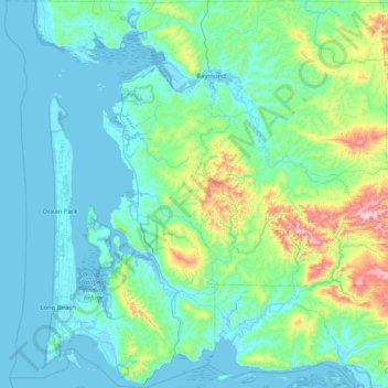
Name: Pacific County topographic map, elevation, terrain.
Location: Pacific County, Washington, United States of America (46.23475 -124.16741 46.79458 -123.35742)
Average elevation: 124 m
Minimum elevation: -4 m
Maximum elevation: 898 m
Other topographic maps
Click on a map to view its topography, its elevation and its terrain.
Lynden
United States of America > Washington > Lynden
Lynden, Whatcom County, Washington, United States of America
Average elevation: 26 m