
Touillon-et-Loutelet topographic map
Interactive map
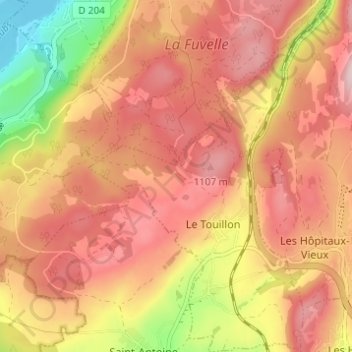
Click on the map to display elevation.
About this map
Name: Touillon-et-Loutelet topographic map, elevation, terrain.
Average elevation: 1,031 m
Minimum elevation: 851 m
Maximum elevation: 1,138 m
Other topographic maps
Click on a map to view its topography, its elevation and its terrain.
Le Loutelet
France > Bourgogne-Franche-Comté > Doubs > Touillon-et-Loutelet > Le Touillon > Le Loutelet
Le Loutelet, Le Touillon, Touillon-et-Loutelet, Pontarlier, Doubs, Bourgogne-Franche-Comté, France métropolitaine, 25370, France
Average elevation: 1,029 m