
Make a donation
Søndre Land topographic map
Click on the map to display elevation.
Make a donation
About this map
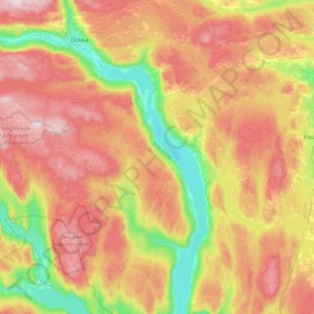
Name: Søndre Land topographic map, elevation, terrain.
Location: Søndre Land, Innlandet, Norway (60.52669 9.97739 60.87878 10.55053)
Average elevation: 461 m
Minimum elevation: 120 m
Maximum elevation: 865 m
Make a donation
Other topographic maps
Click on a map to view its topography, its elevation and its terrain.
Scandinavian Mountains
The mountain chain's highest summits are mostly concentrated in an area (of mean altitude of over 1,000 m) between Stavanger and Trondheim in South Norway, with numerous peaks over 1,300 m and some peaks over 2,000 m. Around Trondheim Fjord, peaks decrease in altitude to about 400–500 m rising again to…
Average elevation: 2,050 m
Galdhøpiggen
At Juvasshytta there is an alpine ski resort with lift on a glacier, reaching an elevation of 2,200 metres (7,200 ft) above sea level, the highest in Scandinavia. It is called Galdhøpiggen Summer Ski Centre and is open from June and all the summer when the road is open.
Average elevation: 2,105 m
Make a donation
Make a donation
Make a donation
Scandinavian Mountains
The mountain chain's highest summits are mostly concentrated in an area of mean altitude of over 1,000 m (3,300 ft),) between Stavanger and Trondheim in South Norway, with numerous peaks over 1,300 m (4,300 ft) and some peaks over 2,000 m (6,600 ft). Around Trondheim Fjord, peaks decrease in altitude to about…
Average elevation: 2,050 m
Make a donation
Make a donation
Make a donation
Galdhøpiggen
At Juvasshytta there is an alpine ski resort with lift on a glacier, reaching an elevation of 2,200 metres (7,200 ft) above sea level, the highest in Scandinavia. It is called Galdhøpiggen Summer Ski Centre and is open from June and all the summer when the road is open.
Average elevation: 2,105 m
Make a donation
Scandinavian Mountains
The mountain chain's highest summits are mostly concentrated in an area of mean altitude of over 1,000 m (3,300 ft),) between Stavanger and Trondheim in South Norway, with numerous peaks over 1,300 m (4,300 ft) and some peaks over 2,000 m (6,600 ft). Around Trondheim Fjord, peaks decrease in altitude to about…
Average elevation: 2,050 m
Make a donation
Make a donation
Make a donation
Glittertinden
The mountain reaches an elevation of 2,452 metres (8,045 ft) without the glacier on top of its peak. As of 2008 it reached 2,465 metres (8,087 ft) above sea level including the glacier, measured as summer minimum. But in August 2022, the mountain was seen basically without the glacier.
Average elevation: 2,135 m
Make a donation
Make a donation
Make a donation
Make a donation
Hamar
Hamar has a humid continental climate (Dfb) with fairly dry and cold winters, and comfortably warm summers. The Hamar II weather station, at an elevation of 141 metres (463 ft), started recording in 1968. The all-time high 33.0 °C (91.4 °F) was recorded in July 2018, which was the warmest month on record…
Average elevation: 267 m
Make a donation
Make a donation
Make a donation
Make a donation
Make a donation
Make a donation
Make a donation