
Waldrode topographic map
Interactive map
Click on the map to display elevation.
Waldrode
Das nach 1785 Theerwisch Wolka genannte Dorf wurde um 1400 gegründet und bestand aus einem Gut sowie ein paar Gehöften. 1874 kam der Ort zum neu errichteten Amtsbezirk Przytullen (polnisch Przytuły), dem er nach 1880 auch getrennt in Landgemeinde und Gutsbezirk angehörte und der – 1938 in „Amtsbezirk Steinhöhe“ umbenannt – bis 1945 zum ostpreußischen Kreis Ortelsburg gehörte.
About this map
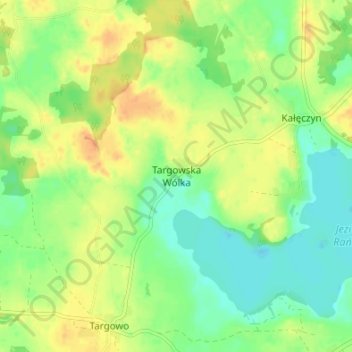
Name: Waldrode topographic map, elevation, terrain.
Average elevation: 156 m
Minimum elevation: 141 m
Maximum elevation: 172 m
Other topographic maps
Click on a map to view its topography, its elevation and its terrain.
Ortelsburg
Polen > Woiwodschaft Ermland-Masuren > powiat szczycieński > Szczytno
Herzog Georg Friedrich, der die Gegend als sein Jagdrevier auserkoren hatte, stoppte die endgültige Zerstörung und baute die Burg ab 1580 zu einem Jagdschloss um. Viele der mit den Bauarbeiten beschäftigten Handwerker ließen sich bei der Burg nieder und gründeten 1581 unabhängig von der bereits…
Average elevation: 150 m