
Dondonay Island topographic map
Interactive map
Click on the map to display elevation.
About this map
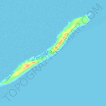
Name: Dondonay Island topographic map, elevation, terrain.
Location: Dondonay Island, Cagayancillo, Mimaropa, 5321, Philippines (9.59123 121.23854 9.62310 121.28102)
Average elevation: 1 m
Minimum elevation: 0 m
Maximum elevation: 41 m
Other topographic maps
Click on a map to view its topography, its elevation and its terrain.
Cavili Island
Cavili Island, Cagayancillo, Mimaropa, 5321, Philippines
Average elevation: 1 m
Patonggong Maliit Island
Patonggong Maliit Island, Balabac, Mimaropa, 5307, Philippines
Average elevation: 0 m
South Mangsee Island
South Mangsee Island, Balabac, Mimaropa, Philippines
Average elevation: 1 m
Lumbucan Island
Lumbucan Island, Balabac, Mimaropa, Philippines
Average elevation: 1 m
Lean Island
Lean Island, Cuyo, Mimaropa, 5318, Philippines
Average elevation: 0 m
Siparay Island
Siparay Island, Magsaysay, Mimaropa, 5319, Philippines
Average elevation: 0 m
Pulaw Talam Island
Pulaw Talam Island, Mimaropa, Philippines
Average elevation: 0 m
Tres Marias Islands
Philippines > Mimaropa > Puerto Princesa
Tres Marias Islands, Puerto Princesa, Mimaropa, 5300, Philippines
Average elevation: 74 m
Ulugan Bay
Philippines > Mimaropa > Buenavista
Ulugan Bay, Buenavista, Puerto Princesa, Mimaropa, Philippines
Average elevation: 0 m
Gabung Island
Gabung Island, Balabac, Mimaropa, Philippines
Average elevation: 3 m
Secam Island
Secam Island, Balabac, Mimaropa, Philippines
Average elevation: 0 m
Parunponon Island
Philippines > Mimaropa > Puerto Princesa
Parunponon Island, Puerto Princesa, Mimaropa, 5300, Philippines
Average elevation: 0 m
Comiran Island
Comiran Island, Balabac, Mimaropa, Philippines
Average elevation: 0 m
Cocoro Island
Cocoro Island, Magsaysay, Mimaropa, 5319, Philippines
Average elevation: 1 m
Langisan Islands
Langisan Islands, Cagayancillo, Mimaropa, 5321, Philippines
Average elevation: 0 m
Quiniluban Island
Quiniluban Island, Agutaya, Mimaropa, 5320, Philippines
Average elevation: 33 m
Candaraman Island
Candaraman Island, Balabac, Mimaropa, Philippines
Average elevation: 2 m
Lubid Island
Lubid Island, Cuyo, Mimaropa, 5318, Philippines
Average elevation: 12 m
Small Pagbo Island
Small Pagbo Island, Mimaropa, Philippines
Average elevation: 0 m
Fondeado Island
Philippines > Mimaropa > Puerto Princesa
Fondeado Island, Puerto Princesa, Mimaropa, 5300, Philippines
Average elevation: 0 m
Indagamy Island
Indagamy Island, Magsaysay, Mimaropa, 5319, Philippines
Average elevation: 0 m
North Verde Island
North Verde Island, Mimaropa, Philippines
Average elevation: 1 m
Nagtabon Beach
Philippines > Mimaropa > Bacungan
Nagtabon Beach, Bacungan-Nagtabon Rd, Bacungan, Puerto Princesa, Mimaropa, Philippines
Average elevation: 67 m
Bacungan
Philippines > Mimaropa > Bacungan
Bacungan, Puerto Princesa, Mimaropa, Philippines
Average elevation: 82 m
Tacbubuc Island
Tacbubuc Island, Magsaysay, Mimaropa, 5319, Philippines
Average elevation: 0 m
Manuc Manucan Island
Manuc Manucan Island, Mimaropa, Philippines
Average elevation: 0 m
Kalungpang Island
Philippines > Mimaropa > Puerto Princesa
Kalungpang Island, Puerto Princesa, Mimaropa, 5300, Philippines
Average elevation: 0 m
Mandit Island
Mandit Island, Agutaya, Mimaropa, 5320, Philippines
Average elevation: 0 m
Meara Island
Philippines > Mimaropa > Puerto Princesa
Meara Island, Puerto Princesa, Mimaropa, 5300, Philippines
Average elevation: 0 m
Maracañao Island
Maracañao Island, Agutaya, Mimaropa, 5320, Philippines
Average elevation: 3 m
Imalaguan Island
Imalaguan Island, Cuyo, Mimaropa, 5318, Philippines
Average elevation: 1 m
Pangatatan Island
Pangatatan Island, Cuyo, Mimaropa, 5318, Philippines
Average elevation: 0 m
North Channel Island
North Channel Island, Mimaropa, Philippines
Average elevation: 0 m
Mansalangan Island
Mansalangan Island, Balabac, Mimaropa, Philippines
Average elevation: 2 m