
Gomery topographic map
Interactive map
Click on the map to display elevation.
About this map
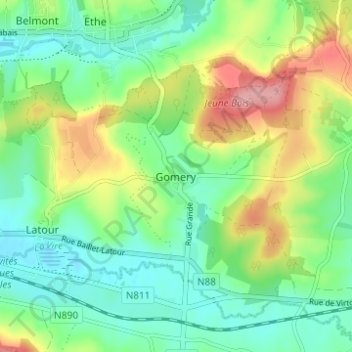
Name: Gomery topographic map, elevation, terrain.
Location: Gomery, Virton, Luxembourg, Wallonie, 6760, Belgique (49.54423 5.57389 49.58423 5.61389)
Average elevation: 246 m
Minimum elevation: 206 m
Maximum elevation: 323 m
Other topographic maps
Click on a map to view its topography, its elevation and its terrain.
Saint-Remy
Belgique > Luxembourg > Virton > Virton
Saint-Remy, Virton, Luxembourg, Wallonie, Belgique
Average elevation: 265 m
Ethe
Belgique > Luxembourg > Virton > Virton
Ethe, Virton, Luxembourg, Wallonie, Belgique
Average elevation: 293 m
Ruette
Belgique > Luxembourg > Virton > Virton
Ruette, Virton, Luxembourg, Wallonie, Belgique
Average elevation: 310 m
Saint-Mard
Belgique > Luxembourg > Virton > Virton
Saint-Mard, Virton, Luxembourg, Wallonie, 6762, Belgique
Average elevation: 272 m