
Glencoe topographic map
Interactive map
Click on the map to display elevation.
About this map
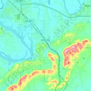
Name: Glencoe topographic map, elevation, terrain.
Location: Glencoe, Etowah County, Alabama, 35905, United States (33.89553 -85.98623 34.00464 -85.88648)
Average elevation: 191 m
Minimum elevation: 150 m
Maximum elevation: 368 m
Other topographic maps
Click on a map to view its topography, its elevation and its terrain.
Gadsden
United States > Alabama > Etowah County
Gadsden, Etowah County, Alabama, United States
Average elevation: 188 m
Dive Land Park
United States > Alabama > Etowah County > Glencoe > Colvin
Dive Land Park, Colvin, Glencoe, Etowah County, Alabama, United States
Average elevation: 228 m
Hopper
United States > Alabama > Etowah County
Hopper, Etowah County, Alabama, United States
Average elevation: 294 m
Rainbow City
United States > Alabama > Etowah County > Rainbow City > Rainbow City
Rainbow City, Etowah County, Alabama, 35906, United States
Average elevation: 178 m
Gadsden
United States > Alabama > Etowah County > Gadsden > Gadsden
Gadsden, Etowah County, Alabama, 35901, United States
Average elevation: 179 m