
Tualatin topographic map
Interactive map
Click on the map to display elevation.
About this map
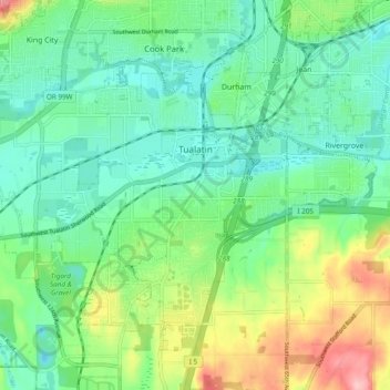
Name: Tualatin topographic map, elevation, terrain.
Location: Tualatin, Washington County, Oregon, 97062, United States (45.34913 -122.81784 45.40262 -122.72191)
Average elevation: 70 m
Minimum elevation: 23 m
Maximum elevation: 181 m
Other topographic maps
Click on a map to view its topography, its elevation and its terrain.
Vern Galaway Memorial Park
United States > Oregon > Washington County > North Plains
Vern Galaway Memorial Park, North Plains, Washington County, Oregon, United States
Average elevation: 56 m
Beaverton
United States > Oregon > Washington County
Beaverton, Washington County, Oregon, United States
Average elevation: 106 m
Cornelius
United States > Oregon > Washington County > Cornelius
Cornelius, Washington County, Oregon, United States
Average elevation: 51 m
Banks
United States > Oregon > Washington County
Banks, Washington County, Oregon, 97106, United States
Average elevation: 70 m
Hillsboro
United States > Oregon > Washington County
Hillsboro, Washington County, Oregon, United States
Average elevation: 53 m
Tigard
United States > Oregon > Washington County
Tigard, Washington County, Oregon, United States
Average elevation: 83 m