
Make a donation
Baguio topographic map
Click on the map to display elevation.
Make a donation
Baguio
In 1903, Filipinos, Japanese and Chinese workers were hired to build Kennon Road, the first road directly connecting Baguio with the lowlands of La Union and Pangasinan. Before this, the only road to Benguet was Naguilian Road, and it was largely a horse trail at higher elevations. Camp John Hay was established in October 1903, after President Theodore Roosevelt signed an executive order setting aside land in Benguet for a military reservation for the United States Army to rest and recuperate from the lowland heat. It was named after Roosevelt's Secretary of State, John Milton Hay.
Make a donation
About this map
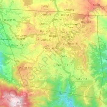
Name: Baguio topographic map, elevation, terrain.
Location: Baguio, Cordillera Administrative Region, 2600, Philippines (16.36062 120.54488 16.43432 120.63549)
Average elevation: 1,371 m
Minimum elevation: 796 m
Maximum elevation: 2,028 m
Make a donation
Other topographic maps
Click on a map to view its topography, its elevation and its terrain.
Make a donation
Make a donation
Make a donation
Santa
Philippines > Ilocos Sur > Santa
The topography of the municipality is undulating to rolling with slope ranging from 0-30%.
Average elevation: 75 m