
Saint-Trond topographic map
Interactive map
Click on the map to display elevation.
About this map
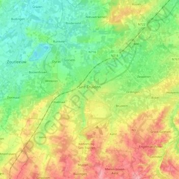
Name: Saint-Trond topographic map, elevation, terrain.
Location: Saint-Trond, Hasselt, Limbourg, Flandre, Belgique (50.74890 5.10658 50.87732 5.28686)
Average elevation: 58 m
Minimum elevation: 20 m
Maximum elevation: 114 m
Other topographic maps
Click on a map to view its topography, its elevation and its terrain.
Saint-Trond
Belgique > Limbourg > Hasselt > Saint-Trond
Saint-Trond, Hasselt, Limbourg, Flandre, Belgique
Average elevation: 54 m
Diepenbeek
Diepenbeek, Hasselt, Limbourg, 3590, Belgique
Average elevation: 44 m
Niel-lez-Saint-Trond
Belgique > Limbourg > Hasselt > Niel-lez-Saint-Trond
Niel-lez-Saint-Trond, Gingelom, Hasselt, Limbourg, Flandre, Belgique
Average elevation: 97 m
Bourg-Léopold
Belgique > Limbourg > Hasselt > Bourg-Léopold
Bourg-Léopold, Hasselt, Limbourg, Flandre, 3970, Belgique
Average elevation: 48 m