
Colliers topographic map
Interactive map
Click on the map to display elevation.
About this map
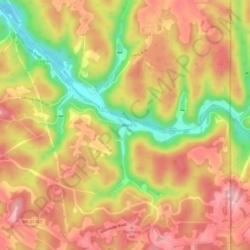
Name: Colliers topographic map, elevation, terrain.
Average elevation: 325 m
Minimum elevation: 225 m
Maximum elevation: 391 m
Other topographic maps
Click on a map to view its topography, its elevation and its terrain.
East Steubenville
United States > West Virginia > Brooke County > Follansbee
East Steubenville, Follansbee, Follansbee District, Brooke County, West Virginia, 26037, United States
Average elevation: 282 m
Bethany
United States > West Virginia > Brooke County
Bethany, Wellsburg District, Brooke County, West Virginia, United States
Average elevation: 294 m
Beech Bottom
United States > West Virginia > Brooke County
Beech Bottom, Wellsburg District, Brooke County, West Virginia, 26030, United States
Average elevation: 275 m
Hooverson Heights
United States > West Virginia > Brooke County > Hooverson Heights
Hooverson Heights, Follansbee District, Brooke County, West Virginia, United States
Average elevation: 274 m
Windsor Heights
United States > West Virginia > Brooke County
Windsor Heights, Wellsburg District, Brooke County, West Virginia, 26075, United States
Average elevation: 263 m
Wellsburg
United States > West Virginia > Brooke County
Wellsburg, Wellsburg District, Brooke County, West Virginia, United States
Average elevation: 268 m
Follansbee
United States > West Virginia > Brooke County
Follansbee, Follansbee District, Brooke County, West Virginia, 26037, United States
Average elevation: 279 m
Virginville
United States > West Virginia > Brooke County
Virginville, Wellsburg District, Brooke County, West Virginia, United States
Average elevation: 305 m
Lazearville
United States > West Virginia > Brooke County > Wellsburg
Lazearville, Wellsburg, Brooke County, West Virginia, 26070, United States
Average elevation: 269 m
Weirton Junction
United States > West Virginia > Brooke County > Weirton Junction
Weirton Junction, Brooke County, West Virginia, 26062-4525, United States
Average elevation: 277 m