
Ivrea topographic map
Interactive map
Click on the map to display elevation.
About this map
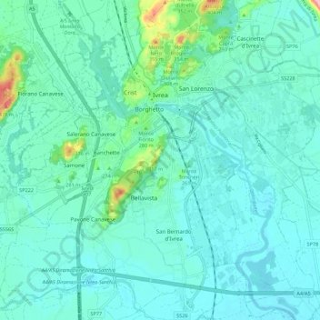
Name: Ivrea topographic map, elevation, terrain.
Location: Ivrea, Turin, Piemont, Italien (45.41318 7.84191 45.49012 7.93073)
Average elevation: 243 m
Minimum elevation: 218 m
Maximum elevation: 382 m
Die Stadt befindet sich am nördlichen Rand der Po-Ebene zwischen Turin und dem Aostatal auf einer Höhe von 253 m s.l.m. Sie liegt am Fuße eines 25 km langen Bergrückens moränischen Ursprungs, bekannt unter dem Namen La Serra. Durch die Stadt fließt der Fluss Dora Baltea. Das Gemeindegebiet umfasst eine Fläche von 30 km².
Other topographic maps
Click on a map to view its topography, its elevation and its terrain.
Ronco Canavese
Ronco Canavese, Turin, Piemont, Italien
Average elevation: 1,854 m
Valprato Soana
Valprato Soana, Turin, Piemont, Italien
Average elevation: 2,115 m