
Delhi topographic map
Interactive map
Click on the map to display elevation.
About this map
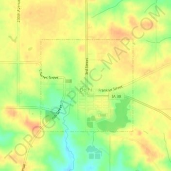
Name: Delhi topographic map, elevation, terrain.
Location: Delhi, Delaware County, Iowa, United States (42.42306 -91.34061 42.43761 -91.32083)
Average elevation: 320 m
Minimum elevation: 293 m
Maximum elevation: 337 m
Other topographic maps
Click on a map to view its topography, its elevation and its terrain.
Ryan
United States > Iowa > Delaware County
Ryan, Delaware County, Iowa, United States
Average elevation: 310 m
Delaware
United States > Iowa > Delaware County
Delaware, Delaware County, Iowa, 52036, United States
Average elevation: 322 m
Greeley
United States > Iowa > Delaware County
Greeley, Delaware County, Iowa, United States
Average elevation: 347 m
Colesburg
United States > Iowa > Delaware County
Colesburg, Delaware County, Iowa, United States
Average elevation: 345 m
York
United States > Iowa > Delaware County
York, Delaware County, Iowa, United States
Average elevation: 340 m
Dundee
United States > Iowa > Delaware County
Dundee, Delaware County, Iowa, United States
Average elevation: 311 m
Backbone State Park
United States > Iowa > Delaware County
Backbone State Park, Delaware County, Iowa, United States
Average elevation: 333 m
Earlville
United States > Iowa > Delaware County
Earlville, Delaware County, Iowa, United States
Average elevation: 310 m
Hopkinton
United States > Iowa > Delaware County
Hopkinton, Delaware County, Iowa, United States
Average elevation: 269 m
Masonville
United States > Iowa > Delaware County
Masonville, Delaware County, Iowa, United States
Average elevation: 309 m
Manchester
United States > Iowa > Delaware County
Manchester, Delaware County, Iowa, 52057, United States
Average elevation: 296 m