
Plémet topographic map
Interactive map
Click on the map to display elevation.
About this map
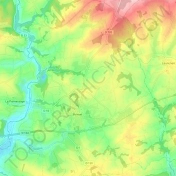
Name: Plémet topographic map, elevation, terrain.
Average elevation: 153 m
Minimum elevation: 77 m
Maximum elevation: 260 m
Other topographic maps
Click on a map to view its topography, its elevation and its terrain.
Le Bos Josselin
France > Bretagne > Côtes-d'Armor > Plémet
Le Bos Josselin, Plémet, Saint-Brieuc, Côtes-d'Armor, Bretagne, France métropolitaine, 22210, France
Average elevation: 132 m
Le Ha
France > Bretagne > Côtes-d'Armor > Plémet
Le Ha, Plémet, Saint-Brieuc, Côtes-d'Armor, Bretagne, France métropolitaine, 22210, France
Average elevation: 147 m
La Ferrière
France > Bretagne > Côtes-d'Armor > Plémet
La Ferrière, Plémet, Saint-Brieuc, Côtes-d'Armor, Bretagne, France métropolitaine, 22210, France
Average elevation: 133 m