
Passau topographic map
Interactive map
Click on the map to display elevation.
About this map
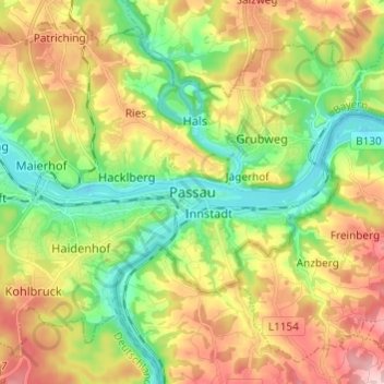
Name: Passau topographic map, elevation, terrain.
Location: Passau, Niederbayern, Bayern, 94032, Deutschland (48.53482 13.42097 48.61482 13.50097)
Average elevation: 380 m
Minimum elevation: 287 m
Maximum elevation: 507 m
Das Klimadiagramm gibt die Daten einer Messstelle in Fürstenzell (südwestlich an Passau angrenzend) wieder. Allerdings liegt diese Messstelle nahezu 100 Meter höher als Passau selbst.
Other topographic maps
Click on a map to view its topography, its elevation and its terrain.
Thanöd
Deutschland > Bayern > Passau
Thanöd, Passau, Bayern, 94034, Deutschland
Average elevation: 358 m
Ries
Deutschland > Bayern > Passau > Ries
Ries, Passau, Bayern, 94034, Deutschland
Average elevation: 366 m
Patriching
Deutschland > Bayern > Passau > Patriching
Patriching, Passau, Bayern, 94113, Deutschland
Average elevation: 387 m
Jägerhof
Deutschland > Bayern > Passau
Jägerhof, Passau, Bayern, 94031, Deutschland
Average elevation: 351 m