
Noord-Brabant topographic map
Interactive map
Click on the map to display elevation.
About this map
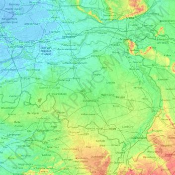
Name: Noord-Brabant topographic map, elevation, terrain.
Location: Noord-Brabant, Nederland (51.22091 4.19012 51.83075 6.04812)
Average elevation: 22 m
Minimum elevation: -7 m
Maximum elevation: 158 m
Other topographic maps
Click on a map to view its topography, its elevation and its terrain.
Utrechtse Heuvelrug
Utrechtse Heuvelrug, Utrecht, Nederland
Average elevation: 10 m
Oostappen
Nederland > Noord-Brabant > Ommel
Oostappen, Ommel, Asten, Noord-Brabant, Nederland, 5756 PW, Nederland
Average elevation: 23 m
Driebergen-Rijsenburg
Driebergen-Rijsenburg, Utrechtse Heuvelrug, Utrecht, Nederland
Average elevation: 8 m
Steenwijk
Steenwijk, Steenwijkerland, Overijssel, Nederland
Average elevation: 4 m
Harderwijk
Nederland > Gelderland > Harderwijk
Harderwijk, Gelderland, Nederland
Average elevation: 7 m
Oud-Beijerland
Oud-Beijerland, Hoeksche Waard, Zuid-Holland, Nederland
Average elevation: 0 m