
潮南区 topographic map
Interactive map
Click on the map to display elevation.
About this map
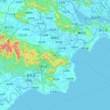
Name: 潮南区 topographic map, elevation, terrain.
Location: 潮南区, 汕头市, 广东省, 中国 (22.98757 116.24004 23.30509 116.89542)
Average elevation: 47 m
Minimum elevation: -3 m
Maximum elevation: 825 m
潮南区为沿海丘陵、平原地区,地势自西南向东北倾斜。地形特征为“一山一江一平原”,即大南山,起于红场镇潘岱村,自西向东延伸,主峰雷岭大山海拔521米。北部隔练江与潮阳区相望,练江自西向东横亘全境,形成练江平原。东部沿海为带状沙滩地。域内海岸线长14.7公里,海域面积4000多平方海里,山地面积38.23万亩,耕地面积20.82万亩。
Other topographic maps
Click on a map to view its topography, its elevation and its terrain.