
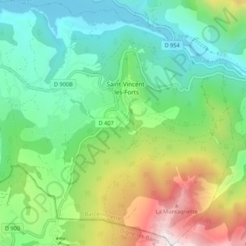
Saint-Vincent-les-Forts topographic map
Interactive map
Click on the map to display elevation.
About this map
Name: Saint-Vincent-les-Forts topographic map, elevation, terrain.
Average elevation: 1,297 m
Minimum elevation: 757 m
Maximum elevation: 2,494 m
Le village est placé à 1 300 m d’altitude, au carrefour des routes de Barcelonnette et d’Embrun, sur un promontoire dominant le lac de Serre-Ponçon.
Other topographic maps
Click on a map to view its topography, its elevation and its terrain.
Fort Saint-Vincent
France > Provence-Alpes-Côte d'Azur > Alpes-de-Haute-Provence > Ubaye-Serre-Ponçon
Fort Saint-Vincent, Route de l'École, Saint-Vincent-les-Forts, Ubaye-Serre-Ponçon, Barcelonnette, Alpes-de-Haute-Provence, Provence-Alpes-Côte d'Azur, France métropolitaine, 04340, France
Average elevation: 1,058 m
Ravin de la Chapelle
France > Provence-Alpes-Côte d'Azur > Alpes-de-Haute-Provence > Ubaye-Serre-Ponçon > Les Terrasses
Ravin de la Chapelle, Les Terrasses, Saint-Vincent-les-Forts, Ubaye-Serre-Ponçon, Barcelonnette, Alpes-de-Haute-Provence, Provence-Alpes-Côte d'Azur, France métropolitaine, 04340, France
Average elevation: 894 m
Sommet de Dormillouse
France > Provence-Alpes-Côte d'Azur > Alpes-de-Haute-Provence > Ubaye-Serre-Ponçon
Sommet de Dormillouse, Ubaye-Serre-Ponçon, Barcelonnette, Alpes-de-Haute-Provence, Provence-Alpes-Côte d'Azur, France métropolitaine, 04340, France
Average elevation: 2,051 m
L'Eygave
France > Provence-Alpes-Côte d'Azur > Alpes-de-Haute-Provence > Ubaye-Serre-Ponçon
L'Eygave, La Bréole, Ubaye-Serre-Ponçon, Barcelonnette, Alpes-de-Haute-Provence, Provence-Alpes-Côte d'Azur, France métropolitaine, 04340, France
Average elevation: 1,264 m
La Bréole
France > Provence-Alpes-Côte d'Azur > Alpes-de-Haute-Provence > Ubaye-Serre-Ponçon
La Bréole, Ubaye-Serre-Ponçon, Barcelonnette, Alpes-de-Haute-Provence, Provence-Alpes-Côte d'Azur, France métropolitaine, 04340, France
Average elevation: 1,045 m
Charamel
France > Provence-Alpes-Côte d'Azur > Alpes-de-Haute-Provence > Ubaye-Serre-Ponçon
Charamel, La Bréole, Ubaye-Serre-Ponçon, Barcelonnette, Alpes-de-Haute-Provence, Provence-Alpes-Côte d'Azur, France métropolitaine, 04340, France
Average elevation: 1,219 m
Le Prayet
France > Provence-Alpes-Côte d'Azur > Alpes-de-Haute-Provence > Ubaye-Serre-Ponçon
Le Prayet, Saint-Vincent-les-Forts, Ubaye-Serre-Ponçon, Barcelonnette, Alpes-de-Haute-Provence, Provence-Alpes-Côte d'Azur, France métropolitaine, 04340, France
Average elevation: 1,274 m
Le Lautaret
France > Provence-Alpes-Côte d'Azur > Alpes-de-Haute-Provence > Ubaye-Serre-Ponçon
Le Lautaret, Saint-Vincent-les-Forts, Ubaye-Serre-Ponçon, Barcelonnette, Alpes-de-Haute-Provence, Provence-Alpes-Côte d'Azur, France métropolitaine, 04340, France
Average elevation: 1,107 m