
Thank you for supporting this site ❤️
Make a donation
Make a donation
Shigatse Prefecture topographic map
Click on the map to display elevation.
Thank you for supporting this site ❤️
Make a donation
Make a donation
About this map
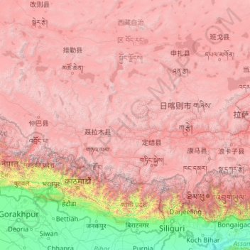
Name: Shigatse Prefecture topographic map, elevation, terrain.
Location: Shigatse Prefecture, Tibet, China (27.21205 82.09907 31.80997 90.34500)
Average elevation: 3,772 m
Minimum elevation: 23 m
Maximum elevation: 8,097 m
Thank you for supporting this site ❤️
Make a donation
Make a donation
Other topographic maps
Click on a map to view its topography, its elevation and its terrain.
Mount Everest
China > Tibet > Qutang > Khumjung
Mount Everest (Chinese: 珠穆朗玛 Zhūmùlǎngmǎ; Nepali: सगरमाथा Sagarmāthā; Tibetan: Chomolungma ཇོ་མོ་གླང་མ) is Earth's highest mountain above sea level, located in the Mahalangur Himal sub-range of the Himalayas. The China–Nepal border runs across its summit…
Average elevation: 7,839 m