
Roy topographic map
Interactive map
Click on the map to display elevation.
About this map
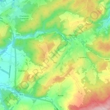
Name: Roy topographic map, elevation, terrain.
Location: Roy, Marche-en-Famenne, Luxembourg, Wallonie, 6900, Belgique (50.15733 5.37790 50.22750 5.47315)
Average elevation: 342 m
Minimum elevation: 240 m
Maximum elevation: 498 m
Other topographic maps
Click on a map to view its topography, its elevation and its terrain.
Château Jemeppe
Belgique > Luxembourg > Marche-en-Famenne > Marche-en-Famenne > Hargimont
Château Jemeppe, 24, Rue Félix Lefèvre, Hargimont, Marche-en-Famenne, Luxembourg, Wallonie, 6900, Belgique
Average elevation: 259 m
Hargimont
Belgique > Luxembourg > Marche-en-Famenne > Marche-en-Famenne > Hargimont
Hargimont, Marche-en-Famenne, Luxembourg, Wallonie, 6900, Belgique
Average elevation: 268 m
Marche-en-Famenne
Belgique > Luxembourg > Marche-en-Famenne > Marche-en-Famenne
Marche-en-Famenne, Luxembourg, Wallonie, 6900, Belgique
Average elevation: 252 m
Waha
Belgique > Luxembourg > Marche-en-Famenne > Marche-en-Famenne
Waha, Marche-en-Famenne, Luxembourg, Wallonie, 6900, Belgique
Average elevation: 265 m
Humain
Belgique > Luxembourg > Marche-en-Famenne > Marche-en-Famenne
Humain, Marche-en-Famenne, Luxembourg, Wallonie, 6900, Belgique
Average elevation: 246 m
Lignières
Belgique > Luxembourg > Marche-en-Famenne > Marche-en-Famenne
Lignières, Marche-en-Famenne, Luxembourg, Wallonie, 6900, Belgique
Average elevation: 355 m