
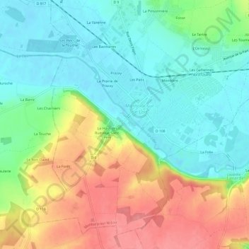
Saint-Oustrille topographic map
Interactive map
Click on the map to display elevation.
About this map
Name: Saint-Oustrille topographic map, elevation, terrain.
Average elevation: 96 m
Minimum elevation: 62 m
Maximum elevation: 148 m
Other topographic maps
Click on a map to view its topography, its elevation and its terrain.
Jardin Saint-Gilles Roseraie
France > Centre-Val de Loire > Loir-et-Cher > Montoire-sur-le-Loir > Saint-Oustrille
Jardin Saint-Gilles Roseraie, Saint-Oustrille, Montoire-sur-le-Loir, Vendôme, Loir-et-Cher, Centre-Val de Loire, France métropolitaine, 41800, France
Average elevation: 91 m
Les Patis
France > Centre-Val de Loire > Loir-et-Cher > Montoire-sur-le-Loir
Les Patis, Montoire-sur-le-Loir, Vendôme, Loir-et-Cher, Centre-Val de Loire, France métropolitaine, 41800, France
Average elevation: 87 m