
Mayor Island topographic map
Interactive map
Click on the map to display elevation.
About this map
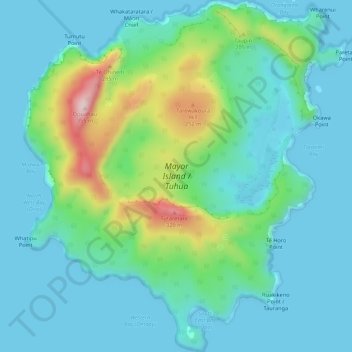
Name: Mayor Island topographic map, elevation, terrain.
Location: Mayor Island, Tauranga, Bay of Plenty, New Zealand (-37.31045 176.23128 -37.26758 176.28073)
Average elevation: 71 m
Minimum elevation: 0 m
Maximum elevation: 344 m
Other topographic maps
Click on a map to view its topography, its elevation and its terrain.
Tauranga
New Zealand > Bay of Plenty > Tauranga
Tauranga, Tauranga City, Bay of Plenty, New Zealand
Average elevation: 10 m
Moturiki Island (Leisure Island)
New Zealand > Bay of Plenty > Tauranga
Moturiki Island (Leisure Island), Tauranga, Bay of Plenty, New Zealand
Average elevation: 8 m
Motiti Island
New Zealand > Bay of Plenty > Tauranga
Motiti Island, Tauranga, Bay of Plenty, New Zealand
Average elevation: 10 m
Lake Aroarotamahine
New Zealand > Bay of Plenty > Tauranga
Lake Aroarotamahine, Tauranga, Tauranga City, Bay of Plenty, New Zealand
Average elevation: 82 m
Yatton Park
New Zealand > Bay of Plenty > Tauranga
Yatton Park, Begonia Way, Merivale, Tauranga, Tauranga City, Bay of Plenty, 3112, New Zealand
Average elevation: 19 m