
兴隆山 topographic map
Interactive map
Click on the map to display elevation.
About this map
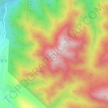
Name: 兴隆山 topographic map, elevation, terrain.
Location: 兴隆山, 城关镇, 榆中县, 兰州市, 甘肃省, 中国 (35.76762 104.06295 35.76772 104.06305)
Average elevation: 2,664 m
Minimum elevation: 2,320 m
Maximum elevation: 2,972 m
五臺山並非一座山,而是座落於「華北屋脊」之上的一系列山峰群,景區面積達2837平方公里,最高海拔3058米。五座山峰(東臺望海峰、南台錦銹峰、中台翠岩峰、西台挂月峰、北台葉斗峰)環抱整片區域,頂無林木而平坦寬闊,猶如疊土之台,故而得名。
Other topographic maps
Click on a map to view its topography, its elevation and its terrain.