
Santa Catarina topographic map
Interactive map
Click on the map to display elevation.
About this map
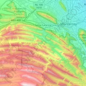
Name: Santa Catarina topographic map, elevation, terrain.
Location: Santa Catarina, Nuevo León, México (25.41353 -100.72979 25.75004 -100.23872)
Average elevation: 1,598 m
Minimum elevation: 470 m
Maximum elevation: 3,704 m
Other topographic maps
Click on a map to view its topography, its elevation and its terrain.
La Jacinta
México > Nuevo León > Santiago
La Jacinta, Santiago, Nuevo León, México
Average elevation: 2,252 m
Benito Juárez
México > Nuevo León > Juárez
Benito Juárez, Juárez, Nuevo León, 67250, México
Average elevation: 395 m
San Pedro Garza García
San Pedro Garza García, Nuevo León, México
Average elevation: 864 m
Monterrey
México > Nuevo León > Monterrey > Monterrey
Monterrey, Nuevo León, 64570, México
Average elevation: 753 m
San Nicolás de los Garza
México > Nuevo León > San Nicolás de los Garza
San Nicolás de los Garza, Nuevo León, 66443, México
Average elevation: 584 m
Guadalupe
México > Nuevo León > Guadalupe
Guadalupe, Nuevo León, 67180, México
Average elevation: 594 m
Cadereyta Jiménez
México > Nuevo León > Cadereyta Jiménez
Cadereyta Jiménez, Nuevo León, 67450, México
Average elevation: 335 m
San Pedro Garza García
México > Nuevo León > San Pedro Garza García
San Pedro Garza García, Nuevo León, 66210, México
Average elevation: 798 m