
Islantilla topographic map
Interactive map
Click on the map to display elevation.
About this map
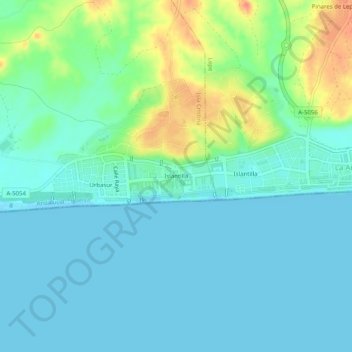
Name: Islantilla topographic map, elevation, terrain.
Average elevation: 12 m
Minimum elevation: -3 m
Maximum elevation: 48 m
Other topographic maps
Click on a map to view its topography, its elevation and its terrain.
Urbasur
España > Andalucía > Costa Occidental > Isla Cristina > Urbasur
Urbasur, Isla Cristina, Costa Occidental, Huelva, Andalucía, 21449, España
Average elevation: 10 m