
Thank you for supporting this site ❤️
Make a donation
Make a donation
Thuringia topographic map
Click on the map to display elevation.
Thank you for supporting this site ❤️
Make a donation
Make a donation
About this map
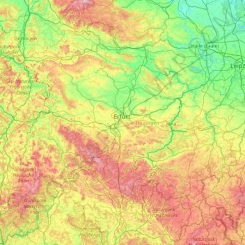
Name: Thuringia topographic map, elevation, terrain.
Location: Thuringia, Germany (50.20435 9.87696 51.64928 12.65392)
Average elevation: 341 m
Minimum elevation: 56 m
Maximum elevation: 1,135 m
Thank you for supporting this site ❤️
Make a donation
Make a donation
Other topographic maps
Click on a map to view its topography, its elevation and its terrain.
Missen - Pšyne
Germany > Brandenburg > Oberspreewald-Lausitz - Górne Błota-Łužyca > Vetschau/Spreewald
Average elevation: 72 m
Thank you for supporting this site ❤️
Make a donation
Make a donation
Wehr (Mosel)
Germany > Rhineland-Palatinate > Landkreis Trier-Saarburg > Palzem > Wehr (Mosel)
Average elevation: 201 m
Leichlingen
Germany > North Rhine-Westphalia > Rheinisch-Bergischer Kreis > Leichlingen > Leichlingen
Average elevation: 95 m
Thank you for supporting this site ❤️
Make a donation
Make a donation