
Grand Port topographic map
Interactive map
Click on the map to display elevation.
About this map
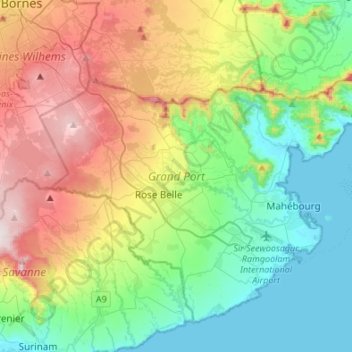
Name: Grand Port topographic map, elevation, terrain.
Location: Grand Port, Mauritius (-20.49533 57.51077 -20.28418 57.78114)
Average elevation: 244 m
Minimum elevation: 0 m
Maximum elevation: 715 m
Other topographic maps
Click on a map to view its topography, its elevation and its terrain.
Port Louis
Port Louis, Outer islands of Mauritius, 11317, Mauritius
Average elevation: 142 m
Mare Longue Reservoir
Mauritius > Plaines Wilhems > Vacoas-Phoenix
Mare Longue Reservoir, Mare Longue track, Vacoas-Phoenix, Plaines Wilhems, 73126, Mauritius
Average elevation: 581 m
Cascade Mare aux Joncs
Mauritius > Plaines Wilhems > Vacoas-Phoenix
Cascade Mare aux Joncs, Vacoas-Phoenix, Plaines Wilhems, Mauritius
Average elevation: 484 m