
Candler-McAfee topographic map
Interactive map
Click on the map to display elevation.
About this map
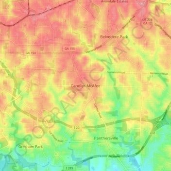
Name: Candler-McAfee topographic map, elevation, terrain.
Location: Candler-McAfee, DeKalb County, Georgia, 30032, United States (33.69192 -84.32341 33.77192 -84.24341)
Average elevation: 288 m
Minimum elevation: 228 m
Maximum elevation: 334 m
Other topographic maps
Click on a map to view its topography, its elevation and its terrain.
Stone Mountain
United States > Georgia > DeKalb County
Stone Mountain, DeKalb County, Georgia, 30087, United States
Average elevation: 299 m
Mason Mill Park
United States > Georgia > DeKalb County > North Druid Hills
Mason Mill Park, North Druid Hills, DeKalb County, Georgia, 30322, United States
Average elevation: 294 m
Habersham
United States > Georgia > DeKalb County
Habersham, DeKalb County, Georgia, 30340, United States
Average elevation: 305 m
North Druid Hills
United States > Georgia > DeKalb County
North Druid Hills, DeKalb County, Georgia, 30329, United States
Average elevation: 291 m
Tucker
United States > Georgia > DeKalb County
Tucker, DeKalb County, Georgia, 30084, United States
Average elevation: 307 m
Dunwoody
United States > Georgia > DeKalb County
Dunwoody, DeKalb County, Georgia, United States
Average elevation: 313 m
North Decatur
United States > Georgia > DeKalb County
North Decatur, DeKalb County, Georgia, 30322, United States
Average elevation: 296 m
Pine Lake
United States > Georgia > DeKalb County
Pine Lake, DeKalb County, Georgia, 30072, United States
Average elevation: 298 m
Brookhaven
United States > Georgia > DeKalb County
Brookhaven, DeKalb County, Georgia, United States
Average elevation: 293 m
Windwood
United States > Georgia > DeKalb County > Dunwoody
Windwood, Dunwoody, DeKalb County, Georgia, 30360, United States
Average elevation: 307 m
Avondale Estates
United States > Georgia > DeKalb County
Avondale Estates, DeKalb County, Georgia, United States
Average elevation: 313 m
Stonecrest
United States > Georgia > DeKalb County
Stonecrest, DeKalb County, Georgia, United States
Average elevation: 258 m
Decatur
United States > Georgia > DeKalb County
Decatur, DeKalb County, Georgia, United States
Average elevation: 308 m
Scottdale
United States > Georgia > DeKalb County
Scottdale, DeKalb County, Georgia, 30079, United States
Average elevation: 302 m
Dunwoody
United States > Georgia > DeKalb County > Dunwoody
Dunwoody, DeKalb County, Georgia, 30338, United States
Average elevation: 309 m
Doraville
United States > Georgia > DeKalb County
Doraville, DeKalb County, Georgia, 30063, United States
Average elevation: 307 m
Chamblee
United States > Georgia > DeKalb County
Chamblee, DeKalb County, Georgia, 30341, United States
Average elevation: 297 m
Candler Lake
United States > Georgia > DeKalb County > North Decatur
Candler Lake, North Decatur, DeKalb County, Georgia, United States
Average elevation: 290 m
Henrico
United States > Georgia > DeKalb County > Henrico
Henrico, DeKalb County, Georgia, 30288, United States
Average elevation: 269 m
WSB-FM (Atlanta)
United States > Georgia > DeKalb County > Atlanta
WSB-FM (Atlanta), New Street Northeast, Candler Park, Atlanta, DeKalb County, Georgia, 30307, United States
Average elevation: 307 m
Tucker
United States > Georgia > DeKalb County > Tucker
Tucker, DeKalb County, Georgia, 30084, United States
Average elevation: 317 m
Redan
United States > Georgia > DeKalb County
Redan, DeKalb County, Georgia, 30088, United States
Average elevation: 283 m
Clarkston
United States > Georgia > DeKalb County
Clarkston, DeKalb County, Georgia, 30021, United States
Average elevation: 307 m
Lithonia
United States > Georgia > DeKalb County
Lithonia, DeKalb County, Georgia, United States
Average elevation: 279 m
Belvedere Park
United States > Georgia > DeKalb County
Belvedere Park, DeKalb County, Georgia, 30032, United States
Average elevation: 297 m