
Barnesville topographic map
Interactive map
Click on the map to display elevation.
About this map
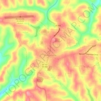
Name: Barnesville topographic map, elevation, terrain.
Location: Barnesville, Belmont County, Ohio, 43713, United States (39.97840 -81.19332 40.00137 -81.14410)
Average elevation: 369 m
Minimum elevation: 300 m
Maximum elevation: 412 m
Other topographic maps
Click on a map to view its topography, its elevation and its terrain.
Bellaire
United States > Ohio > Belmont County
Bellaire, Belmont County, Ohio, United States
Average elevation: 283 m
Belmont
United States > Ohio > Belmont County
Belmont, Belmont County, Ohio, United States
Average elevation: 361 m
Warnock
United States > Ohio > Belmont County
Warnock, Belmont County, Ohio, 43967, United States
Average elevation: 337 m
Barton
United States > Ohio > Belmont County
Barton, Belmont County, Ohio, 43905, United States
Average elevation: 315 m
Bethesda
United States > Ohio > Belmont County
Bethesda, Belmont County, Ohio, United States
Average elevation: 376 m
Bridgeport
United States > Ohio > Belmont County
Bridgeport, Belmont County, Ohio, United States
Average elevation: 244 m
Glencoe
United States > Ohio > Belmont County
Glencoe, Belmont County, Ohio, 43928, United States
Average elevation: 317 m
Holloway
United States > Ohio > Belmont County
Holloway, Belmont County, Ohio, 43985, United States
Average elevation: 313 m
Brookside
United States > Ohio > Belmont County
Brookside, Belmont County, Ohio, United States
Average elevation: 281 m
Blaine
United States > Ohio > Belmont County
Blaine, Belmont County, Ohio, 43909, United States
Average elevation: 310 m
Lafferty
United States > Ohio > Belmont County
Lafferty, Belmont County, Ohio, 43951, United States
Average elevation: 344 m
Lloydsville
United States > Ohio > Belmont County
Lloydsville, Belmont County, Ohio, 43972, United States
Average elevation: 360 m
Alledonia
United States > Ohio > Belmont County
Alledonia, Belmont County, Ohio, 43902, United States
Average elevation: 320 m
Centerville
United States > Ohio > Belmont County
Centerville, Belmont County, Ohio, United States
Average elevation: 362 m
Badgertown
United States > Ohio > Belmont County
Badgertown, Belmont County, Ohio, 43719, United States
Average elevation: 366 m
Flushing
United States > Ohio > Belmont County
Flushing, Belmont County, Ohio, United States
Average elevation: 365 m
Bannock
United States > Ohio > Belmont County
Bannock, Belmont County, Ohio, 43972, United States
Average elevation: 339 m
Morristown
United States > Ohio > Belmont County
Morristown, Belmont County, Ohio, 43759, United States
Average elevation: 374 m
Lansing
United States > Ohio > Belmont County
Lansing, Belmont County, Ohio, 43934, United States
Average elevation: 297 m
Neffs
United States > Ohio > Belmont County > Neffs
Neffs, Belmont County, Ohio, 43940, United States
Average elevation: 300 m
Boston
United States > Ohio > Belmont County
Boston, Belmont County, Ohio, United States
Average elevation: 366 m
Captina
United States > Ohio > Belmont County
Captina, Belmont County, Ohio, United States
Average elevation: 289 m
Wolfhurst
United States > Ohio > Belmont County
Wolfhurst, Belmont County, Ohio, 43934, United States
Average elevation: 296 m
Jacobsburg
United States > Ohio > Belmont County
Jacobsburg, Belmont County, Ohio, 43933, United States
Average elevation: 356 m
Shadyside
United States > Ohio > Belmont County
Shadyside, Belmont County, Ohio, United States
Average elevation: 245 m
St. Clairsville
United States > Ohio > Belmont County
St. Clairsville, Belmont County, Ohio, 43950, United States
Average elevation: 355 m
Powhatan Point
United States > Ohio > Belmont County
Powhatan Point, Belmont County, Ohio, United States
Average elevation: 241 m
Yorkville
United States > Ohio > Belmont County
Yorkville, Belmont County, Ohio, 43971, United States
Average elevation: 256 m
Piedmont Lake
United States > Ohio > Belmont County
Piedmont Lake, Belmont County, Ohio, United States
Average elevation: 321 m
Martins Ferry
United States > Ohio > Belmont County
Martins Ferry, Belmont County, Ohio, United States
Average elevation: 288 m