
La Barraque topographic map
Interactive map
Click on the map to display elevation.
About this map
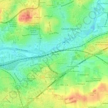
Name: La Barraque topographic map, elevation, terrain.
Average elevation: 46 m
Minimum elevation: 23 m
Maximum elevation: 78 m
Other topographic maps
Click on a map to view its topography, its elevation and its terrain.
Le Chêne Morand
France > Bretagne > Ille-et-Vilaine > Cesson-Sévigné
Le Chêne Morand, Cesson-Sévigné, Rennes, Ille-et-Vilaine, Bretagne, France métropolitaine, 35510, France
Average elevation: 46 m
La Salmondière
France > Bretagne > Ille-et-Vilaine > Cesson-Sévigné
La Salmondière, Cesson-Sévigné, Rennes, Ille-et-Vilaine, Bretagne, France métropolitaine, 35510, France
Average elevation: 65 m
Bouriande
France > Bretagne > Ille-et-Vilaine > Cesson-Sévigné
Bouriande, Cesson-Sévigné, Rennes, Ille-et-Vilaine, Bretagne, France métropolitaine, 35510, France
Average elevation: 51 m
Bout de Mare
France > Bretagne > Ille-et-Vilaine > Cesson-Sévigné > Bout de Mare
Bout de Mare, Cesson-Sévigné, Rennes, Ille-et-Vilaine, Bretagne, France métropolitaine, 35510, France
Average elevation: 46 m
La Boulais
France > Bretagne > Ille-et-Vilaine > Cesson-Sévigné
La Boulais, Cesson-Sévigné, Rennes, Ille-et-Vilaine, Bretagne, France métropolitaine, 35510, France
Average elevation: 49 m
Bourgchevreuil
France > Bretagne > Ille-et-Vilaine > Cesson-Sévigné
Bourgchevreuil, Cesson-Sévigné, Rennes, Ille-et-Vilaine, Bretagne, France métropolitaine, 35510, France
Average elevation: 46 m
Le Verger
France > Bretagne > Ille-et-Vilaine > Cesson-Sévigné
Le Verger, Cesson-Sévigné, Rennes, Ille-et-Vilaine, Bretagne, France métropolitaine, 35510, France
Average elevation: 50 m