
Thank you for supporting this site ❤️
Make a donation
Make a donation
Astane topographic map
Click on the map to display elevation.
Thank you for supporting this site ❤️
Make a donation
Make a donation
About this map
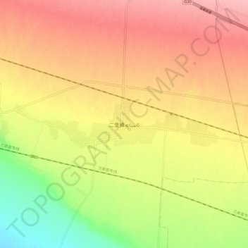
Name: Astane topographic map, elevation, terrain.
Location: Astane, Hami, Xinjiang, China (42.92077 93.12991 43.00077 93.20991)
Average elevation: 819 m
Minimum elevation: 747 m
Maximum elevation: 873 m
Thank you for supporting this site ❤️
Make a donation
Make a donation
Other topographic maps
Click on a map to view its topography, its elevation and its terrain.
Barköl Kazakh Autonomous County
Barkol Kazakh Autonomous County spans a total area of 38,400 square kilometres (14,800 mi2), including 25,500 square kilometres (9,800 mi2) of mountains and the Gobi Desert, accounting for 66% of the total area of the autonomous county. The terrain is high in the southeast and low in the northwest, with an…
Average elevation: 1,436 m