
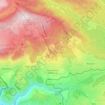
Font-Romeu-Odeillo-Via topographic map
Interactive map
Click on the map to display elevation.
About this map
Name: Font-Romeu-Odeillo-Via topographic map, elevation, terrain.
Average elevation: 1,733 m
Minimum elevation: 1,256 m
Maximum elevation: 2,215 m
Other topographic maps
Click on a map to view its topography, its elevation and its terrain.
Thuès-Entre-Valls
França > Occitânia > Pyrénées-Orientales
Thuès-Entre-Valls, Prades, Pyrénées-Orientales, Occitânia, França metropolitana, 66360, França
Average elevation: 1,570 m
Prades
França > Occitânia > Pyrénées-Orientales > Prades
Prades, Pyrénées-Orientales, Occitânia, França metropolitana, 66500, França
Average elevation: 453 m
Corsavy
França > Occitânia > Pyrénées-Orientales
Corsavy, Céret, Pyrénées-Orientales, Occitânia, França metropolitana, 66150, França
Average elevation: 953 m
Caixas
França > Occitânia > Pyrénées-Orientales > Caixas
Caixas, Céret, Pyrénées-Orientales, Occitânia, França metropolitana, 66300, França
Average elevation: 372 m