
Sichuan topographic map
Interactive map
Click on the map to display elevation.
About this map
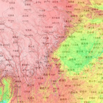
Name: Sichuan topographic map, elevation, terrain.
Location: Sichuan, China (26.04817 97.34738 34.31471 108.54267)
Average elevation: 2,522 m
Minimum elevation: 140 m
Maximum elevation: 6,536 m
Due to great differences in terrain, the climate of the province is highly variable. In general, it has strong monsoonal influences, with rainfall heavily concentrated in the summer. Under the Köppen climate classification, the Sichuan Basin (including Chengdu) in the eastern half of the province experiences a humid subtropical climate (Köppen Cwa or Cfa), with long, hot, wet summers and short, mild to cool, dry, and cloudy winters. Consequently, it has China's lowest sunshine totals. The western region has mountainous areas producing a cooler but sunnier climate. Having cool to very cold winters and mild summers, temperatures generally decrease with greater elevation. However, due to its high altitude and its inland location, many areas such as Garze County and Zoige County in Sichuan exhibit a subarctic climate (Köppen Dwc)- featuring extremely cold winters down to −30 °C and even cold summer nights. The region is geologically active with landslides and earthquakes. Average elevation ranges from 2,000 to 3,500 meters; average temperatures range from 0 to 15 °C. The southern part of the province, including Panzhihua and Xichang, has a sunny climate with short, very mild winters and very warm to hot summers.
Other topographic maps
Click on a map to view its topography, its elevation and its terrain.
Nam Tin
China > Hong Kong > Islands District > Tai O
Nam Tin, Tai O, Islands District, New Territories, Hong Kong, China
Average elevation: 146 m
Sai Kung District
Sai Kung District, New Territories, Hong Kong, China
Average elevation: 29 m
Daocheng County
Daocheng County, Kardze, Sichuan, 627700, China
Average elevation: 3,926 m
先头梁子
China > Yunnan > Malipo County
先头梁子, Malipo County, Wenshan, Yunnan, China
Average elevation: 1,241 m
Islands District
Islands District, New Territories, Hong Kong, China
Average elevation: 36 m
Upper Yubeng
China > Yunnan > Dêqên County > Yunling
Upper Yubeng, Yunling, Dêqên County, Diqing, Yunnan, China
Average elevation: 3,560 m
Kashgar Prefecture
China > Xinjiang > Kashgar City
Kashgar Prefecture, Kashgar City, Kachgar, Xinjiang, 844000, China
Average elevation: 2,275 m
Dengkou County
Dengkou County, Bayannur City, Inner Mongolia, China
Average elevation: 1,140 m
Shunde District
Shunde District, Foshan, Guangdong Province, China
Average elevation: 5 m
Lake Lingge
China > Tibet > Shuanghu County > Garco
Lake Lingge, Garco, Shuanghu County, Nagqu City, Tibet, China
Average elevation: 5,096 m
Huadu District
China > Guangdong Province > Guangzhou City
Huadu District, Guangzhou City, Guangdong Province, 510800, China
Average elevation: 56 m
Fuding
China > Fujian > Fuding > Tongshan Subdistrict
Fuding, Tongshan Subdistrict, Fuding, Ningde City, Fujian, 355200, China
Average elevation: 279 m
Ho Man Tin East Service Reservoir Playground
Ho Man Tin East Service Reservoir Playground, Lo Lung Hang, Ho Man Tin, Kowloon City District, Kowloon, Hong Kong, China
Average elevation: 22 m
Maralbexi County
Maralbexi County, Kachgar, Xinjiang, China
Average elevation: 1,296 m
Elzet Ul Township
China > Xinjiang > Hejing County
Elzet Ul Township, Hejing County, Bayingolin, Xinjiang, China
Average elevation: 3,131 m